By Pam Selbert
First in the series of four features on Historic Old U.S. 80. Join us on a year long journey along this scenic route, with a little history of the old road tossed in as we trace the path that linked East and West Coasts before the first interstate highways were constructed.
There was a time not long ago–as recently as the mid-1960s that if you were traveling from San Diego, California to Savannah, Georgia, chances are good you followed U.S. Highway 80 the entire way.
But times changed, and today the old coast-to-coast route, at least as original U.S. 80, is no more. It was decommissioned in chunks over the years, first in California, then Arizona, New Mexico and finally much of Texas. After 1991, the highway once billed as the “shortest and straightest road across the country” officially went to farther west than Dallas.
The Boulevard of America
U.S. 80, dubbed the “Boulevard of America” for the dozens of towns it ran through, was part of the “inaugural class’ of U.S. highways. It was new as a numbered highway in 1926, although its route (except for the stretch between El Paso and Sweetwater, Texas) was virtually identical to an earlier road, the Dixie Overland Highway.
The Dixie Overland Highway had been conceived in Savannah in 1914 as a coast-to-coast road that would “never be snowbound” and within three years was plotted to the Pacific, crossing eight states and 75 counties, each which agreed to build and maintain the year-round highway. A press release at the time noted that the Dixie Overland Highway would connect “Oglethorpe’s trail (in Georgia) with the Balboa’s scrutiny (the Pacific), allowing the spirit of De Soto to continue its westward march not hampered by unbridged streams, tackles forests and burning deserts.”
A Better Plan
By the early 1920s more than 250 named routes crisscrossed the country, north to south, east to west, some of which included the Dixie Overland Highway or sections of it–such as the Bankhead National Highway, Jefferson Davis National Highway, Lee Highway, Old Spanish Trail, Ocean to Ocean Highway, Broadway of America–and the system was confusing.
In 1926, the American Association of State Highway Officials (AASHO) approved a plan to number some 200 highways, and the now-familiar shield began appearing on signposts. The first official description of U.S. Highway 80, a 2,726-mile route, was released the following year. The eight-mile extension was added two years later. And for nearly four decades, U.S. 80 began at Pacific Highway and Market Street in San Diego and ended at Butler Avenue and Tybrisa Street on Tybee Island. About 150 miles of the historic route can be driven in California, where in 2006, through the efforts of the San Diego East Visitors Bureau, the old road was designated a Historic California Highway and the U.S. 80 shields began going back up.
Our Trip Begins
A good place to start the trip is at the southern tip of Point Lorna Peninsula, where the Cabrillo National Monument commemorates the landing of Juan Rodriguez Cabrillo at San Diego in September 1542, the first European expedition to set foot on what would be the west coast of the United States. Nearly 400 years later the 14-foot tall sandstone statue, which shows Cabrillo gazing at the bay, was donated by the Portuguese government. Old Fort Lorna Lighthouse, in operation from 1854 to 1891 (when a new one was built), is here at the highest point of the park, 422 feet above sea level.
Headed east from the lighthouse, you will pass a host of shops, restaurants and points of interest (see sidebar). These include a colorful street fair on Adams Avenue and the San Diego Classic Portuguese explorer Juan Rodriguez Cabillo landed at the site of San Diego in 1542. Car Collection on El Cajon Boulevard. Numerous antique shops and restaurants are in the historic La Mesa downtown, as is La Mesa Depot Train Museum. You’ll find the historic cultural center in El Cajon and the Olaf Wieghorst Western Heritage Center. If you’re hungry after your museum tour, a number of fine restaurants in the area offer Mexican, Italian and traditional fare. Head toward Lake Jennings where the county park offers a campground. Continue east to Summer’s Past Farms, where a wealth of herb gardens and crafts displays is worth a stop. Continue east, climbing steeply into the mountains of East County and the town of Alpine to visit the museum at the Historical Society headquarters.
Mountain Vistas
Old Highway 80 continues up the mountain to the Cleveland National Forest and Viejas Indian Reservation, home to, a band of Kumeyaay Indians. Viejas Casino and Viejas Outlet Center (a free program is held at the water court here most evenings) are here, as is an RV park. This is spectacular mountain country, tier upon tier of blue hills folding to the horizon, nearer brown slopes polka-dotted green with scrub pines and junipers.
Proceed on Old Highway 80 into Descanso junction. There just north of the road on Highway 79 is squat Raintree Market; a world of chainsaw sculptures, tempting produce and a jumble of other items for sale. Continue through chaparral Oak Tree Forest, a surreal world of dwarf trees typical of this dry region, and past the turn-off to Cuyamaca State Park (well worth a visit). just west of Guatay several sections of the road, including original culverts, date from 1917.
The road continues through the S67,000-acre Cleveland National Forest, Southern California’s last wilderness, a home to mountain lions, deer and other wild critters, and a variety of pines. just over a century ago, President Theodore Roosevelt signed the declaration that created the Cleveland National Forest. Work is currently underway to remove nonnative, invasive tamarisk trees and replace native species, willows, cottonwoods and meadow grasses.
Valley Views
Historic 80 continues east, through Pine Valley, down the steep grade to Buckman Springs (Boulder Oaks, a Forest Service campground, is ahead; the Pacific Crest hiking trail winds through the area) and on to La Posta Indian Reservation (La Posta Casino and Golden Acorn Casino are here) and Campo Indian Reservation.
Continue to the town of Boulevard (a visit to Wisteria Candy Cottage is recommended) and on to Bankhead Springs, named for Alabama Senator john Bankhead, Sr., who helped pass the Federal Aid Road Act of 1916; his granddaughter Tallulah Bankhead, an early film star, had a home here. The old road dips close to the Mexico border then returns north over the pass to sleepy jacumba, where just west of town a short stretch of original concrete remains. In jacumba, an old spa fed by hot springs has been restored and is a popular attraction.
Ahead, in a world of massive, fractured-granite shapes, is the town of ln-Ko-Pah (Native American for “People of the Hills”). Cross the interstate and follow the frontage road to round, stone Desert Tower, which rises in a gritty landscape of rocks and boulders, yellow grass and spiked cholla, and enjoys fine views of this rugged terrain. The odd folk-art tower, a California Registered Historical Landmark, was built by Bert Vaughn of Jacumba in 1922-23 to commemorate the pioneers. and the road and railroad builders who opened the area A small admission fee is charged to tour the tower.
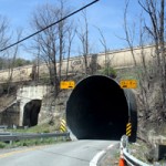
Remnants of the old road remain but are broken up by 1-8 as it arcs down the escarpment into the desert. Here you must return to the· interstate to drive the long grade down the San Diego East Mountains into Imperial County. Take the Ocotillo exit toward Plaster City, where sheet rock building materials are made. En route you can see sections of the, old road where sand has mounded and desert shrubs now grow. The Butterfield Overland Stage Route ran nearby.
Dixieland, straight ahead, is the produce capital of Southern California, the vast fields watered by the Colorado River through complex irrigation systems. The old road continues straight east into Seeley, then El Centro, a community of Spanish-style buildings and abundant restaurants. Continue east through the desert to Hohville and on to Gordons Well, where you must return to the interstate. Running parallel just to the south is the All American Canal, the conduit for Colorado River water into Imperial Valley, and the area’s only water source.
Daunting Desert Dunes
Interstate 8 furrows east through the Algodones Dunes or Imperial Sand Dunes Recreation Area. These towering waves of sand were once so daunting to travelers a nationally famous engineer told the State Highway Commission that trying to build a road through them “was the most asinine thing he ha~ ever heard of.” However, a passable road east was needed, and in 1912 a plank road was built through “little Sahara,” the eight-mile-wide, 80-mile-long strip of blowing, shifting sand. Remnants of the old road near Grays Well remain. Travelers must stay on 1-8 to exit 159 but they can drive the old road to Sidewinder Road. Return to the interstate and at exit 166 return to Old Highway 80 and continue across the All American Canal on the 1936 All American Canal Bridge.
The remains of an old stagecoach horse exchange on the Butterfield line are nearby, fawn-colored adobe walls that seem to have partly melted, with holes up high for the now non-existent roof timbers. Continue along the old road to the 1914 “Ocean to Ocean” bridge. The bridge, refurbished and reopened in 2002, is alternating one-lane across the Colorado River Into Yuma, Arizona The 1923 railroad trestle parallel to the old bridge is the main route today for UP and BN & SF freight trains en route to El Centro and San Diego.
South of the river, Yuma Territorial Prison (now a state park at Giss Parkway and Prison Hill Road), was home to many of Arizona’s dangerous and notorious criminals from 1876 to 1909, and today is one of Arizona’s most-visited attractions. Another popular attraction is the 1865 Yuma Quartermaster Depot, also now a state park and home to the Yuma· visitor Center at 210 North 4th Street.
Yuma, a town of 120,000, offers ~any other attractions and the 170 campgrounds in the area make that easy. And so for now, Yuma is the end of the line.