Mystery, Majesty, and Memories Reward the RVer Who Plans Ahead
by David and Ritsuko Robinson
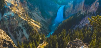
A cowboy emerges from a forest–and stops in his tracks. “Wow!” he blurts. “Somethin’ sure happened!” Whether fact or folklore, the old-timer stands awestruck at the brink of one of the world’s great natural wonders, the stupendous Grand Canyon.
Somethin’ sure did happen. An ancient river kept flowing while the lowland around it slowly rose. It was like pushing a layer cake up while holding the cake knife still. Five or six million years of erosion widened the slice to a yawning canyon. Now, in the strata that stripe its walls, you can read our planet’s autobiography from the time before life to the day of your visit, a span of some two billion years.
The canyon-carving is still going on. Grain by tiny grain, the land is rinsed out of the canyon by the Colorado River, so heavy with silt it looks like latte. I once crept gingerly behind archaeologist Doug Schwartz across a spine of rock connecting the North Rim to a pedestal he called Sky Island. “How much higher was this knife-edge when the Indians crawled across it?” I asked. “Not an inch,” he said. “And they didn’t crawl,” he added with a grin. So no rush; you can visit a decade from now and the Grand Canyon will look the same.
Buy why wait a decade? Don’t go tomorrow, however—unless you’ve planned ahead, made reservations and gotten your rig in tiptop shape for the demands of high desert driving. The North Rim closes in winter, but the South is a rim for all seasons. Go in May to mid-June or September to mid-October if you can; both rims are open, the weather is best, and you’ll dodge the winter challenges and summer crowds. You may need to plan a year ahead. Maybe two. Depends on what you want to do. Let’s look at the menu. You’ll probably approach from Interstate Route 40, driving north from Williams on wonderfully scenic Route 64 for about 60 miles to the South Rim. For a loftier vista, take U.S. Route 180 northwest from Flagstaff, hang a right to Arizona Snowbowl, and ride the chairlift to the 11,500-foot level of Agassiz Peak. From there, if you have time, stamina, and a big water bottle, you can tramp nine miles round-trip to the tundra atop Humphreys Peak, Arizona’s 12,633-foot cupola. Then continue on Routes 180 and 64 to the Grand Canyon National Park entrance. Inside you’ll find a visitor center, shops, and facilities from ATM to gas station clustered in Grand Canyon Village.
Near Tusayan you’ll pass Ten-X Campground, the IMAX Theater, and an airport. Or maybe you won’t pass. The Ten-X takes RVs (no hookups or reservations, and it’s seldom full), and the theater wows audiences with its sensory overload. And for sights you can’t see from an RV, swoop like an eagle down into the canyon in a light plane or helicopter from the airport.
Maybe your eagle eye will glimpse a little green side canyon with crystal waterfalls and shimmering pools. Want to visit this Shangri-La? Tour operators will take you by helicopter or hiking trail for a few days in Havasu Canyon, home of the Havasupai people for 800 years. Their name says it all; it means “People of the blue-green waters.”
There’s another name that says it all: the Skywalk, a glass floored footbridge jutting from the rim into dizzying space, with the canyon floor 4,000 feet straight down between your feet. It’s at Grand Canyon West at the far end of the park, a tiring drive by RV but a short and pricey hop by air. You can get just as dizzy on the back of a mule, and a lot closer to the heart and soul of nature’s wonderwork. If you’re at least four-foot-seven and at most 200 pounds fully dressed, the park’s sure-footed mules will take you in a group down cliff-edge trails for a day trip partway or an overnight adventure to Phantom Ranch at the bottom, where some of the famous raft rides begin. If it’s warm on the rim, it can be 120° at river level, but hey, the mule is doing the work. And doing it carefully, you hope, as the mules calmly stop, turn tails to the canyon wall, and pose with heads hanging over the abyss for a group photo. Reserve a mule a year ahead; 23 months for the Phantom Ranch ride. Your backside will remember the trip for a week, but you’ll need no photos to remember it for a lifetime.
The South Rim has three campgrounds. Trailer Village has hookups and Mather has a dump station; both are open year-round and reservations are a must Desert View, 26 miles east, has no hookups, takes no reservations, and closes mid-October to mid-May. There are commercial campgrounds outside the park; the nearest is Camper Village in Tusayan.
The park’s free shuttles link Mather and Trailer Village to the stunning overlooks, trailheads, and attractions along roads closed in summer to private vehicles without an accessibility permit. Get up early for sunrise photos, stay up late for sunset and moonlight shots, take a hike, watch the birds, and feel the canyon’s mood change with every nuance of sun and cloud.
You see the North Rim across the gorge, a thousand feet higher and only ten miles away, but you haven’t seen the views from there. Only one visitor in ten ever does. Be the one.
Where Route 64 tees into Route 89, you could head south to “Flag,” with a scenic detour to Wupatki National Monument, a Painted Desert overlook, and the once-firebreathing Sunset Crater; then east on I-40 to Meteor Crater, where an ancient impact punched another awesome hole in the ground.
Head north instead. It’s 215 miles of driving to end up ten miles across the canyon, but worth every mile. You’ll hold your breath on the soaring Navajo Bridge over Marble Canyon, where the Grand Canyon begins. You may spot a coyote or a scampering roadrunner. And a gravel sidetrack into the boonies here and there may tempt you to go exploring. But unless you’re driving a toy carrier with ATVs inside, drive on by. You’ll get lost, you’ll blow a tire, you’ll overheat, it’ll rattle your rig and shake your teeth loose, you’ll wash away in a flash flood, or all of the above. A dirt road gets slick really quick, so if a rainstorm has wet it, forget it— or regret it. There’s plenty to see and do on roads that are ready for you.
North on Route 89, west on 89A, then south on 67 to North Rim Campground a mile from the brink— it’s a long but lovely run through forest and rangeland, past layered cliffs, weathered ruins, heart-stopping vistas, and campgrounds you can backtrack to, if you didn’t reserve at North Rim or you prefer hookups; it has none. But you’ll revel in what the North Rim does have. Mule rides along the edge or partway down; Kaibab squirrels found nowhere else on the planet; the historic North Rim Lodge; trails and viewpoints and fewer people to share them with; and a view not even the South Rim can beat, a staggering, eye-popping, wraparound panorama from Bright Angel Point that is beyond words. Except this one: Go.