Hoover Dam
Construction began in 1931 and Hoover Dam was completed in 1936. It still stands tall as an engineering marvel high above the Colorado River between Arizona and Nevada.

Photo courtesy Arizona-leisure
Named one of the Top 10 Construction Achievements of the 20th Century, Hoover Dam attracts over 7 million visitors from around the world every year.
A National Historic Landmark, Hoover Dam is the highest concrete dam in the Western Hemisphere, standing at 725 feet in height and 1,244 feet in length. At its base, Hoover Dam is 660 feet thick which is 60 feet longer than two football fields laid end-to-end. Combined with its top thickness of 45 feet, there is enough concrete (4.5 million cubic yards) in Hoover Dam to build a two-lane highway from Seattle, Washington to Miami, Florida. Or imagine a four-foot wide sidewalk around Earth at its equator.
With 17 generators producing 4 billion kilowatts of electricity a year, it also is one of the country’s largest hydroelectric power facilities.
Hoover Dam Bypass Project
Background

The Hoover Dam Bypass Project is on budget at $240 million. Photo courtesy hooverdambypass.org
United States Highway 93 (U.S. 93) has been designated a North American Free Trade Agreement (NAFTA) route. The increasing congestion caused by the switchbacks leading to the Hoover Dam site and the restrictions at the dam crossing have led to the development of the Hoover Bypass Project.
The Hoover Dam Bypass Project is a 3.5-mile corridor beginning at approximately milepost 2.2 in Clark County, Nevada and crossing the Colorado River approximately 1,500 feet downstream of the Hoover Dam, and terminating in Mohave County, Arizona near milepost 1.7 on U.S. 93.
Some key facts
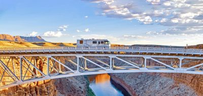
- Arch span is 1,060 feet in length
- Bridge is 1,900 feet in length
- Bridge deck and sidewalk is located approximately 900 feet above the Colorado River
- Bridge is located approximately 1,500 feet south of Hoover Dam
Project information

Construction progress July 2010. Photo courtesy hooverdambypass.org
The Hoover Dam Bypass is made up of six distinct, yet overlapping, phases of Bypass construction:
- Relocation of portions of the Western Area Power Administration (WAPA) transmission system and switchyard
- Arizona approach—2 miles of bypass roadway
- Nevada approach—3 miles of bypass roadway
- Colorado River Bridge (Mike O’Callaghan-Pat Tillman Memorial Bridge)
- Interim surfacing of Bypass
- Final surfacing of roadway tie-ins
Construction of the Bypass remains on schedule for opening to traffic in November 2010.
The Bridging America Event at Hoover dam is scheduled for October 16, 2010. To continue reading about this special event, click here.
Worth Pondering…
Think big. There are unforeseen forces ready to support your dreams.
—Cheryl Richardson
Follow Rex via: Twitter / Facebook / StumbleUpon
If you enjoyed this article, you might also wish to read
Quartzsite 2011 RV show dates announced
Chino Valley chamber president steps down to support RV Park, AZ
Riparian Preserve honored as top birding spot, AZ
Okanagan, the Napa of the North, BC, Part 2
If you enjoy these articles and want to read more on RV travels and lifestyle, visit my new website: Vogel Talks RVing.