By Bob Difley
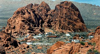
With Snowbird season in its waning moments, RVers are starting to head north to cooler weather, many of which will head for the national forests for a change of scene from the Southwestern Deserts.
Many retreating snowbirds, though, choose a more leisurely pace to the northern climes than multiple hundred-mile days of driving, heading for higher elevations and cooler weather in some of the southern parts of the country. Northern Arizona’s Coconino National Forest, for example, lies north of Payson to above Flagstaff and up to Humphreys Peak, the highest point in Arizona at 12,633 feet, about 10 miles north of Flagstaff.
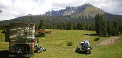
There are plentiful areas in the national forest for both boondocking and in forest service campgrounds.
However, Coconino is well on the way to fully implementing its Travel Management Plan that designates which forest roads you can drive on and where you can boondock. These dispersed camping areas are identified on free maps available at ranger stations and online.

I received the following email from Mike Dechter, the Litigation Coordinator of Coconino NF, with updates and other information on camping in the Coconino National Forest that may be of some help if you are heading in that direction.
On April 15, the Coconino National Forest issued a revised, free Motor Vehicle Use Map to show all of the roads, trails and areas open to motor vehicle use on the Forest. The Motor Vehicle Use Map is re-issued each year, is free to the public, and can be downloaded for use on smartphones, tablets and Garmin GPS devices. Copies of the Motor Vehicle Use Map will be available at all Coconino National Forest Offices, nearby national forest offices, and other local businesses.In addition to hard copy maps, forest visitors can now get a free Coconino National Forest Travel Map, which is an electronic color map with shaded relief topography, game management units, hiking trails, and all designated motorized routes and areas. When using this map with the Avenza PDF Maps App, this map is GPS-enabled meaning you can see where you are on the map as you drive or hike on the national forest. Instructions for how to get the free map and app on your mobile device can be found at http://go.usa.gov/PEa (case sensitive).The 2014 Motor Vehicle Use Map includes a number of updates and corrections made as a result of public input received over the past year. More substantive route changes requested by the public will need to be reviewed through the National Environmental Policy Act (NEPA) process. The forest expects to propose changes to the system of designated motor vehicle routes and areas in late 2014 to begin the NEPA process.If you discover errors on the 2014 Motorized Vehicle Use Map, notice problems with road signs on the Coconino National Forest, or have any general comments about motorized use policies or designations, please visit the website and complete the “Feedback” form, at http://go.usa.gov/Qww.For additional information, please contact the Coconino National Forest at 928-527-3600.Sincerely,Mike Dechter____________________________________Mike DechterCoconino National ForestNEPA, Appeals, and Litigation Coordinator928-527-3416On April 15, the Coconino National Forest issued a revised, free Motor Vehicle Use Map to show all of the roads, trails and areas open to motor vehicle use on the Forest. The Motor Vehicle Use Map is re-issued each year, is free to the public, and can be downloaded for use on smartphones, tablets and Garmin GPS devices. Copies of the Motor Vehicle Use Map will be available at all Coconino National Forest Offices, nearby national forest offices, and other local businesses.
In addition to hard copy maps, forest visitors can now get a free Coconino National Forest Travel Map, which is an electronic color map with shaded relief topography, game management units, hiking trails, and all designated motorized routes and areas. When using this map with the Avenza PDF Maps App, this map is GPS-enabled meaning you can see where you are on the map as you drive or hike on the national forest. Instructions for how to get the free map and app on your mobile device can be found at http://go.usa.gov/PEa (case sensitive).
The 2014 Motor Vehicle Use Map includes a number of updates and corrections made as a result of public input received over the past year. More substantive route changes requested by the public will need to be reviewed through the National Environmental Policy Act (NEPA) process. The forest expects to propose changes to the system of designated motor vehicle routes and areas in late 2014 to begin the NEPA process.
If you discover errors on the 2014 Motorized Vehicle Use Map, notice problems with road signs on the Coconino National Forest, or have any general comments about motorized use policies or designations, please visit the website and complete the “Feedback” form, at http://go.usa.gov/Qww.
For additional information, please contact the Coconino National Forest at 928-527-3600.
Sincerely,
Mike Dechter
Coconino National Forest
NEPA, Appeals, and Litigation Coordinator
The Coconino National Forest is worthy of a detour as you head north, and you may find it hard to leave. Happy Travels.
For more RVing articles and tips take a look at my Healthy RV Lifestyle website, where you will also find my ebooks: BOONDOCKING: Finding the Perfect Campsite on America’s Public Lands (PDF or Kindle), 111 Ways to Get the Biggest Bang for your RV Lifestyle Buck (PDF or Kindle), and Snowbird Guide to Boondocking in the Southwestern Deserts (PDF or Kindle), and my newest, The RV Lifestyle: Reflections of Life on the Road (Kindle reader version). NOTE: Use the Kindle version to read on iPad and iPhone or any device that has the free Kindle reader app.