This is the eighth in a continuing series about our trip through Canada to Alaska
Wednesday our travels took us out of the Jasper National Forest of British Columbia, Canada, and into pastureland. The absolutely stunning vistas we have been exposed to for the past few days have faded into memory, with the help of pictures, and now we’re on to new horizons.
The 185-mile drive wasn’t anything to yawn about. It still held our interest, but the towering peaks of the Canadian Rockies and Caribou Mountains that lined the left and right of the highway had much less snow and fewer precipitous faces than we had seen for the past week.
What kept us scanning the roadsides today? Well, Mama black bear and two 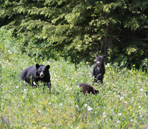 cubs paused from their browsing to check us out. An elk went springing across an open expanse, thrusting on its hind legs.
At an Ancient Cedar Forest we hiked into a recently found grove of Western Red Cedars made up of tall trees believed to be between 1,000 and 2,000 years old. At the end of one part of the trail is a “BIG TREE.” And it really is big: 16 feet in diameter. Interpretive signs 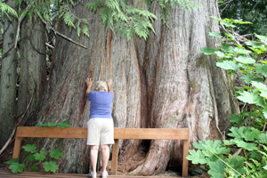 along the path answered questions we didn’t remember asking. One of my favorite bits of information was that cedars grow in circles for unknown reasons, somewhat like “crop circles and fairy circles.”
The grove was thick with cedars and mosquitoes, because nature puts cedars in damp places, also the natural habitat of ‘skeeters.
And one more stop before we headed to our rendezvous campground for the evening. Exiting the town of McBride, B.C., we crossed the highway to take a look at carvings by a local eccentric who displays his artwork at the 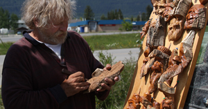 highway intersection. Monique found several characters she would have liked to adopt but settled on one, now called Chief O’Darda!, named after the carver.
Since you’ll be driving through Canada on your way to Alaska, it’s a good idea to know conversions. I was trying to buy bread for a shilling and six pence, but was corrected. It costs five dollars. How many liters of air do you put in your tyres? Okay, that’s all nonsense, but it’s a good idea to become familiar with Canadian conversions before you enter our neighbor’s country.
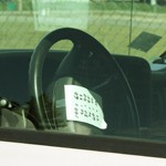 Most important is knowing speed limits. It’s probably on your speedometer, but it might be hard to find when you need it. I taped the conversions to my steering wheel. Distances are in kilometers, each of which equals 0.62 of a mile. Each 3.78 litres of fuel equals a gallon. It’s also convenient to have a chart for temperature and weights.
More about costs here. It’s not all as bad as you might think. Gas is about 83 to 97 cents a liter, but today we paid $2.00 a liter at the top of a mountain. I only put in four liters or $8 for less than one gallon. For reference, today we hit 1,000 miles on the trip at a total cost of $225 for diesel, which is about the same as regular, and we average 10.9 mpg.

One Less 'Skeeter in the Cedar Forest
Several commenters to these blogs have suggested I add a map of our route. Between the traveling, touring, blog-writing and trying to keep up with regular chores, it may take a few days to comply, but I will put together a map soon.
Incidentally, today our caravan grew to 18 rigs, with four couples joining us. Our wagonmaster, tailgunner and their wives hosted a potluck get-acquainted dinner on the lawn of our campground.
From the “Never-Bored RVers,” We’ll see you on down the road.
boat rentals in orange county
Fortunately for me, I have done this trip with my family and I. It was amazing and yes there is no radio reception in the mountains once you get out in the wilderness. Alaska is the last frontier in America and I hope it intends to stay that way. Thank you for the article.
Pingback: flyttstädning stockholm
Lennie
Sirius radio is the only radio that will work in the mountains – LOL just don’t let your subscription run out half way thru the Pine Pass like I did. Makes for a boring solo trip with no music when its raining! Lucky guys we loved our Trip to Alaska and you make us want to pack up and head there again.
jim
like your story. makes me want to pack 5th wheel and head to alaska again.very nice scenery all the way.
robert
Correction, I said we are the largest importer of your oil and gas, we are the LARGEST SUPPLIER OF YOUR OIL AND GAS. Unfortunately, it does cost a little more up here:)
robert
Barry and Monique,
I wouldn’t lay it on so thick with the conversions. You are travelling through Canada, your largest trading partner and the largest importer or your oil and gas. I own two cars, each showing kilometers per hour in large font and miles per hour in smaller font. Conversely, my class A motorhome, purchased in the USA has miles per hour in large font than the kilometers per hour which are also shown. If you find it necessary to tape the conversions to your steering wheel you are probably challenged, and for those unfortunates who actually are, I won’t detail how. Enjoy your travels through the second largest country in the world, after Russia, and try not to obsess over the fact that you are not in the USA. You will enjoy the experience much more, and not sound like the stereotypical, obnoxious, American tourist that has been portrayed in so many of your movies.
Dick and Cindy
On our trip up the Al-Can to Alaska in early 2009 we happened through a town that looked like it was having a festival and it had all these wonderful wood carvings everywhere as we drove through. I looked it up in our travel book and saw that this was the annual wood carving festival in McBride. Unfortunately, Dick didn’t like all the crowds and vehicles and so we didn’t get to stop! I think it should be one of the many things/events to consider in planning a trip up there!
Nancy
Have enjoyed your travels and am revisiting our journey to Canada/Alaska last year. It was all absolutely incredible.
I’m interested in what camera you are using. There are some amazing pictures.
Enjoy
Mary Dale Underwood
I lived in Alaska for 12 years and have driven the Alcan twice. Reading your blog makes me want to hitch-up my travel trailer and join you. Thank you for your wonderful blog, I look forward reading everyone several times. Hopefully by this time next year i’ll have a truck and join a group heading north.
Have a safe one ….. mare
Chris Clarke
Sorry for the lousy spelling – I will make a better effort to proofread if I post again. Age and rapidly disappearing grey cells might be my only defence.
Chris Clarke
It looks like you’re headed along the Yellowhead Highway (16) and will be going through Prince George (PG – probrbly already there). At that point you have two options to get to Alaska – heading north up to Dawson Creek (Mile Zero of the Alaska Highway) or continuing west to a place called Kitwanga where you can head up the Stewart-Cassiar highway that ties in to the Alaska highway about 20 Kms west of Watson Lake north of the 60th Parallel.
The Stewart-Cassiar highway (#37) is very scenic but the road is rougher than the one out of Dawson Creek, but many RVer’s have taken it both ways. If you’re going the Stewart-Cassiar route and drive a diesel there’s a few things to know. From McBride to PG there is no place really to get diesel and the price of gasoline along that route is outrageous. At PG things and prices get a lot more civilized (it’s just the odor from the local pulp mills that you may have to deal with) Should you go west from PG the next place for fuel would be Vanderhoof and no problem on to Burns Lake, but past Burns Lake it gets a bit dicey for diesel so planning ahead is important.
Housto (BC) may be your next planned stop for diesel but there is only one location for it (the UFA Co-op) and they are not open on weekends. It’s a card access location but the attendant will help you to fill up and pay via credit card or cash. For some reason, Shell & Husky both shut down service stations in Houston and Shell closed down in Smithers as well.
If you are in this area you have reached some more glorious scenery and one of the prime steelhead fishing areas in the Pacific Northwest. I have made an annual pilgrimage to the Bulkley and some of the other rivers around there for the past twenty 5 years and will be back there at the end of September again.
If you go north out of Prince George enjoy the Alaska Highway that the troops built back in wartime as a strategic need.
Happy to hear that you enjoy our part of “God’s Country”.
PS: Google Earth can give a good overview of the routings.