


The country is full of beautiful and diverse natural wonders, but sometimes you come across a place that makes you feel you’ve teleported to a different planet. Over millions of years, nature has had plenty of time to work its magic, transforming the earth into out-of-this-world geological wonders. From ancient seas and rivers to volcanic explosions and receding glaciers, North America’s transformation has created some incredible — and bizarre — geology.
1) Goblin Valley State Park, Utah

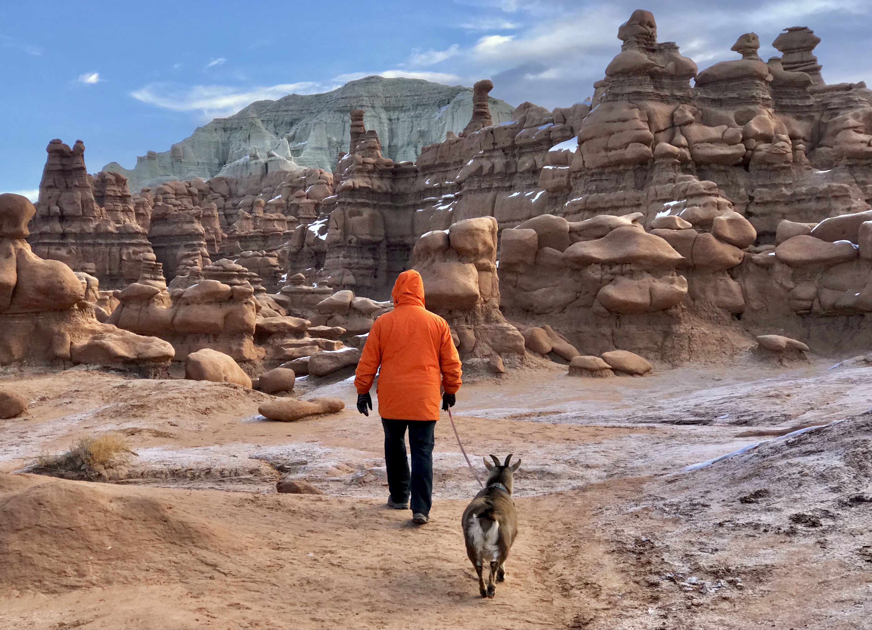
Chad and Frankie the goat hiking around the Valley of the Goblins. @CateBattles
Lesser known than the national parks, but one of Utah’s greatest gems is Goblin Valley located in the San Rafael desert. Though a little off the beaten path, this is a place you won’t want to miss and is a perfect stop between Capitol Reef National Park and Moab. The 3,654-acre park features thousands of “goblin-esque” hoodoos, maze-like canyons, as well as caves to explore. The unusual shaped rock formations are the result of weathering Estrada sandstone deposited during the Jurassic period, 180-140 million years ago, when it was situated along an ancient sea.
Though there are a few trails, the best feature of the park is Valley of Goblins, where you can choose your own adventure, as there’s no official trail. Here, you can wander around the goblin, mushroom, and castle-shaped rocks on your own. Additionally, like most Utah state parks, Goblin Valley is pet-friendly, so bring Fido! Along with hiking, rappel into the Goblin Lair, bike the trail system, and take advantage of their incredible disc-golf course.
2) Pacific Coast, Oregon

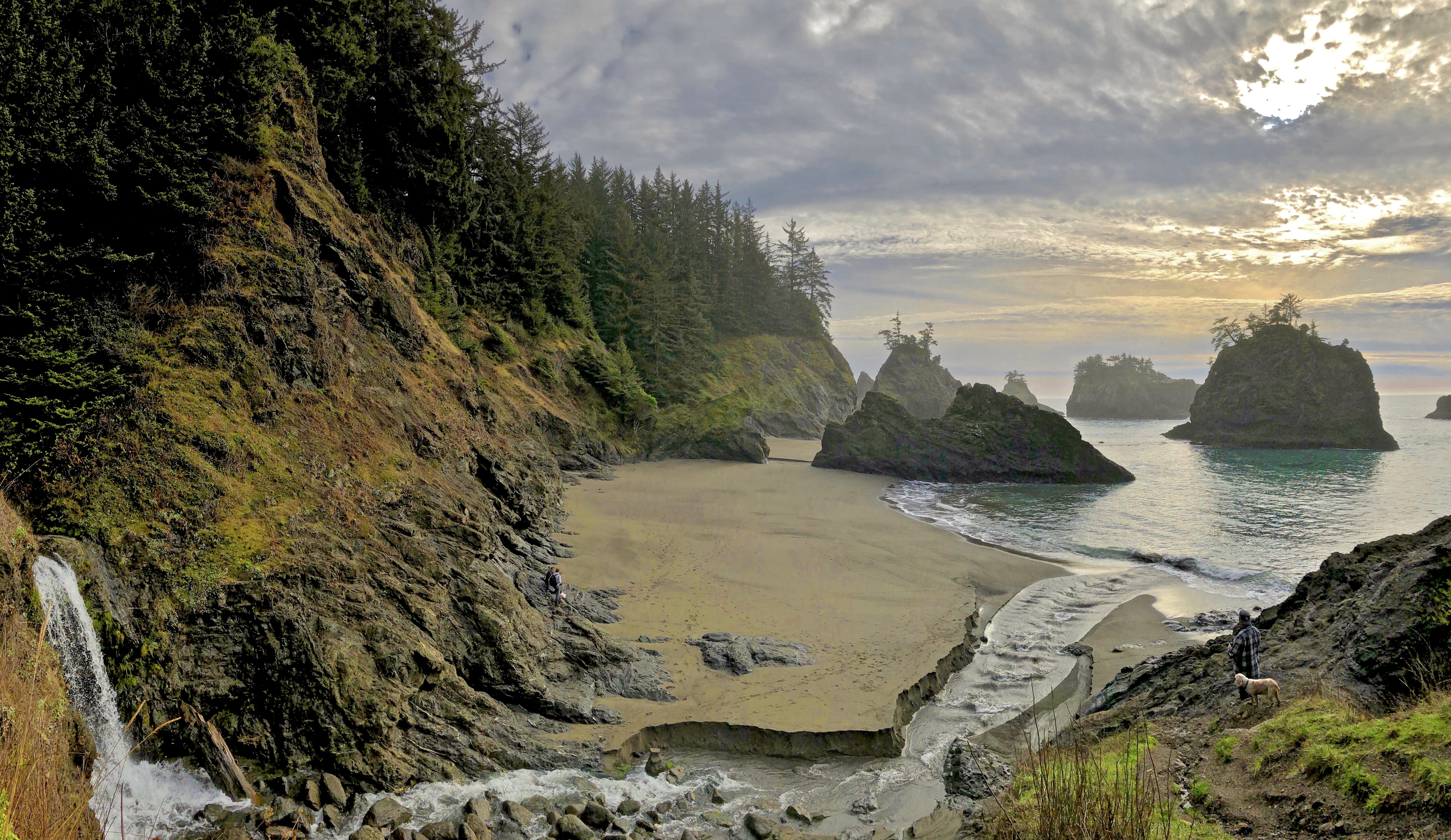
A waterfall at the Samuel Boardman Scenic Corridor. @CateBattles
When it comes to incredible geology, the Oregon Coast has the rest of the U.S. shorelines beat. The 363-miles of public coastline from Brookings to Astoria showcases diverse geographical features, including haystack rocks, sea caves, towering sand dunes, basalt cliffs, and rugged chasms. With a mix of ocean sediment and lava flows, the coastline is full of spectacular rock formations, a result of both violent upheaval and gradual wearing over time. For millions of years, the Yellowstone Hotspot spurred countless volcanic explosions around the Pacific Northwest, sending lava flows from hundreds of miles east to the Pacific Ocean. Additionally, tectonic activity related to the Cascadian Subduction Zone created fissures in the earth’s crust, forming underwater volcanoes. Over time, the water levels have changed, rocks have submerged and reemerged, and the ebb and flow are evident in the layered formations you see today.
While visiting Oregon’s shore, don’t miss the Samuel Boardman Scenic Corridor along the Southern Coast, which features countless haystacks, natural bridges, and sea caves. Further north, explore Devils Punchbowl, Cape Perpetua, Hug Point, and Cape Kiwanda.
3) Bisti Badlands, New Mexico

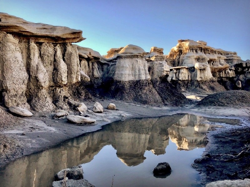
Unusual rock formations in the Bisti Badlands. @CateBattles
Located south of Farmington, New Mexico, this unique landscape is home to a maze of hoodoos and phantasmagoric rock formations right out of an alien world. The Bisti De-Na-Zin Wilderness, situated in the San Juan Basin, formed over the course of 550 million years as sediment was left from seas, swamps, and rivers and later sculpted by uplifting forces and erosion. Within these 45,000 acres of wilderness, totem poles of sandstone reach for the sky as bizarre egg-shaped rocks are scattered around the badlands. Remnants of an ancient forest can be seen in the petrified juniper and other conifers spread around the desolate landscape, as well as fossils of prehistoric creatures and plants that inhabited this once lush area.
This region can get incredibly hot during the summer, and due to the lack of vegetation and shade, the best time to visit is early in the morning or late afternoon. Sunrise and sunset are ideal times for photography as the light makes the orange, pinks, blues and greys pop. While hiking, remember to bring plenty of water and a GPS.
4) Yellowstone’s Prismatic Spring, Wyoming

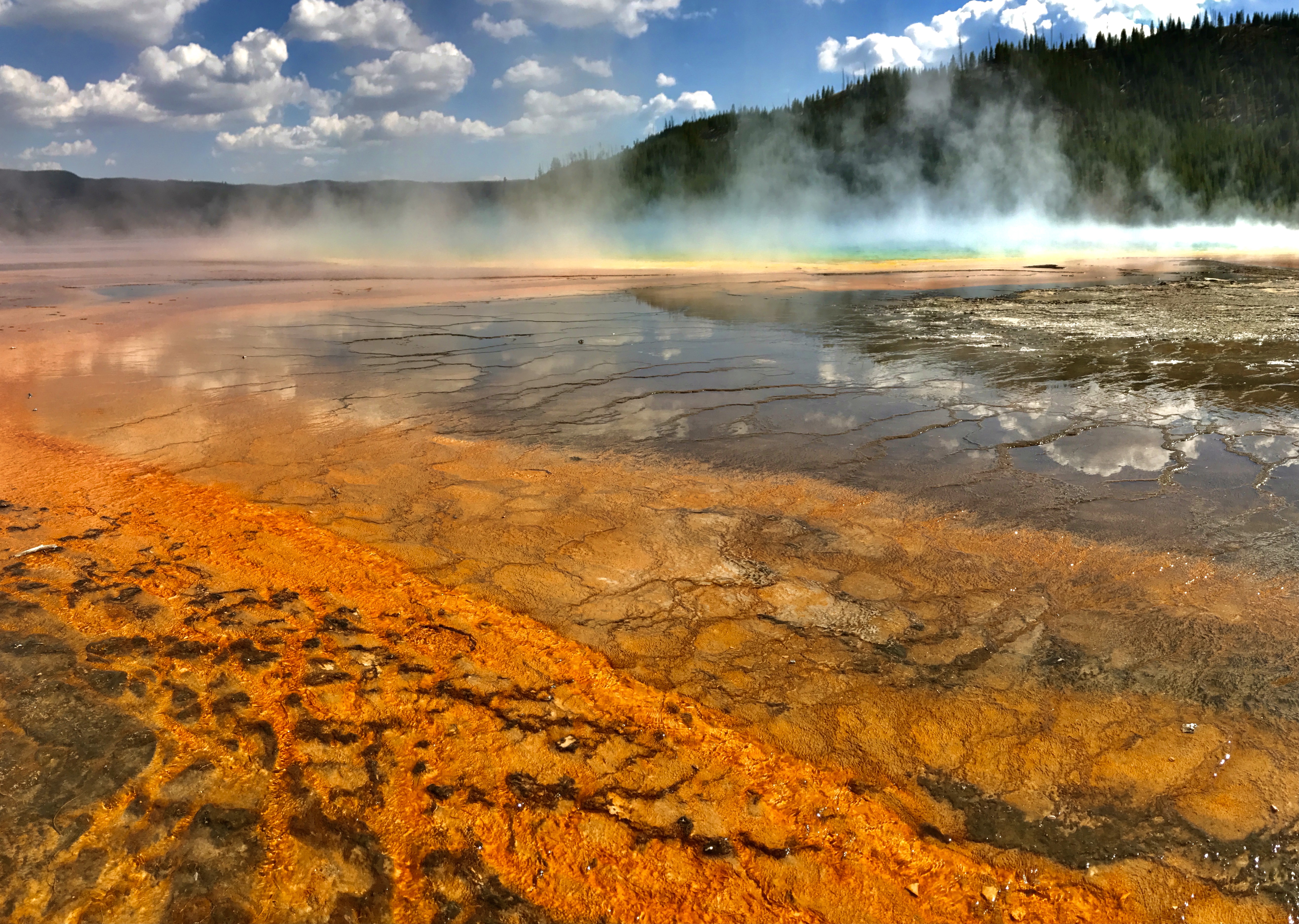
The Grand Prismatic Spring in Yellowstone National Park. @CateBattles
Undoubtedly the most famous on the list, Yellowstone National Park is internationally renowned for its geothermal features and happens to be the world’s first national park. For over 150 million years, various geological processes have helped create Yellowstone’s landscape, including volcanic explosions, glacial carving, and weathering erosion. Though most of the volcanic activity occurs at the boundary of two tectonic plates like the Ring of Fire, Yellowstone is unique because it’s centrally located on the North American Plate. Despite its far proximity from the plate boundary, it’s home to one of the Earth’s largest supervolcanos. Hotspots, like the one under Yellowstone, are created when a rift causes a plume of the warm mantle to rise from the Earth’s core. This shallow source of magma heats the ground and water above, creating over 10,000 hydrothermal features, including geysers, mud pots, hot springs and fumaroles scattered around the park.
While exploring Yellowstone, beat the crowds by catching the sunrise at Grand Prismatic Spring, take the South Rim Trail to Lower Falls, and enjoy a scenic drive north to Mammoth Hot Springs.
5) Craters of the Moon, Idaho

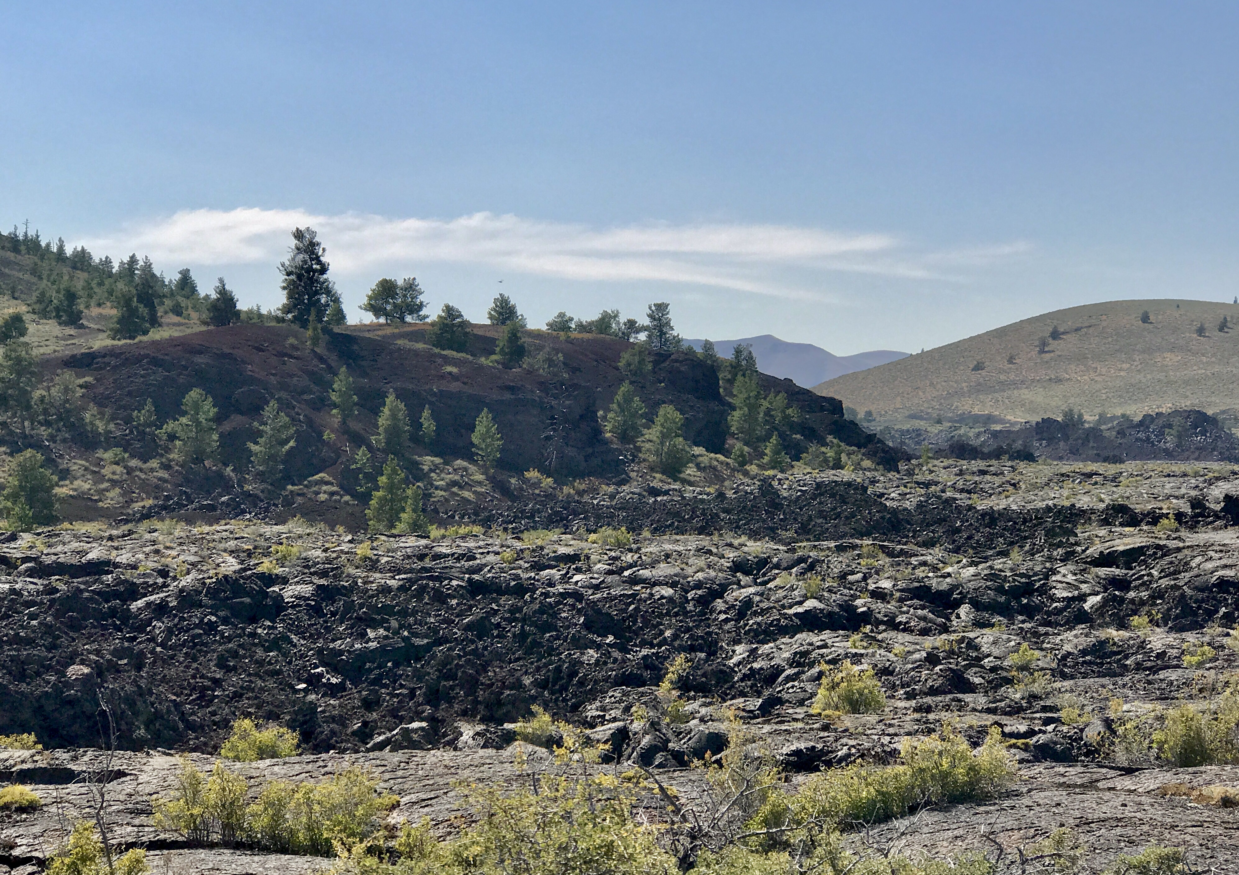
One of the many lava fields at Craters of the Moon National Park. @CateBattles
Strikingly different from the rest of Idaho’s landscape, you’ll definitely feel like you’ve landed on some alien moon with its vast ocean of lava rock stretching as far as the eye can see. It’s understandable why the Apollo astronauts prepared for their mission to the moon there! This 750,000-acre national monument and preserve is a geological wonderland, where you can explore 13,000 years of lava flows, cinder cones, lava tubes and caves. Unlike typical volcanoes, the lava in this region came out of fissures in the ground where there’s a 53-mile-long weak spot in the earth called the Great Rift. Over thousands of years, many eruptions have taken place along the open cracks of the rift, sending lava hundreds of feet into the air. Though there are dozens of lava fields within the park, the largest one can be found at the Craters of the Moon lava field, which is made up of 60 different lava flows and 25 volcanic cinder cones, covering 613 square miles.
During your visit, take the 7-mile scenic loop road that gives you a glimpse of some of the park’s best features. Experience a lava tube firsthand by hiking to Indian Tunnel, Boy Scout Cave, Beauty Cave, and Buffalo Cave. Other great trails include Broken Top and Inferno Cone.
6) Bryce Canyon National Park, Utah

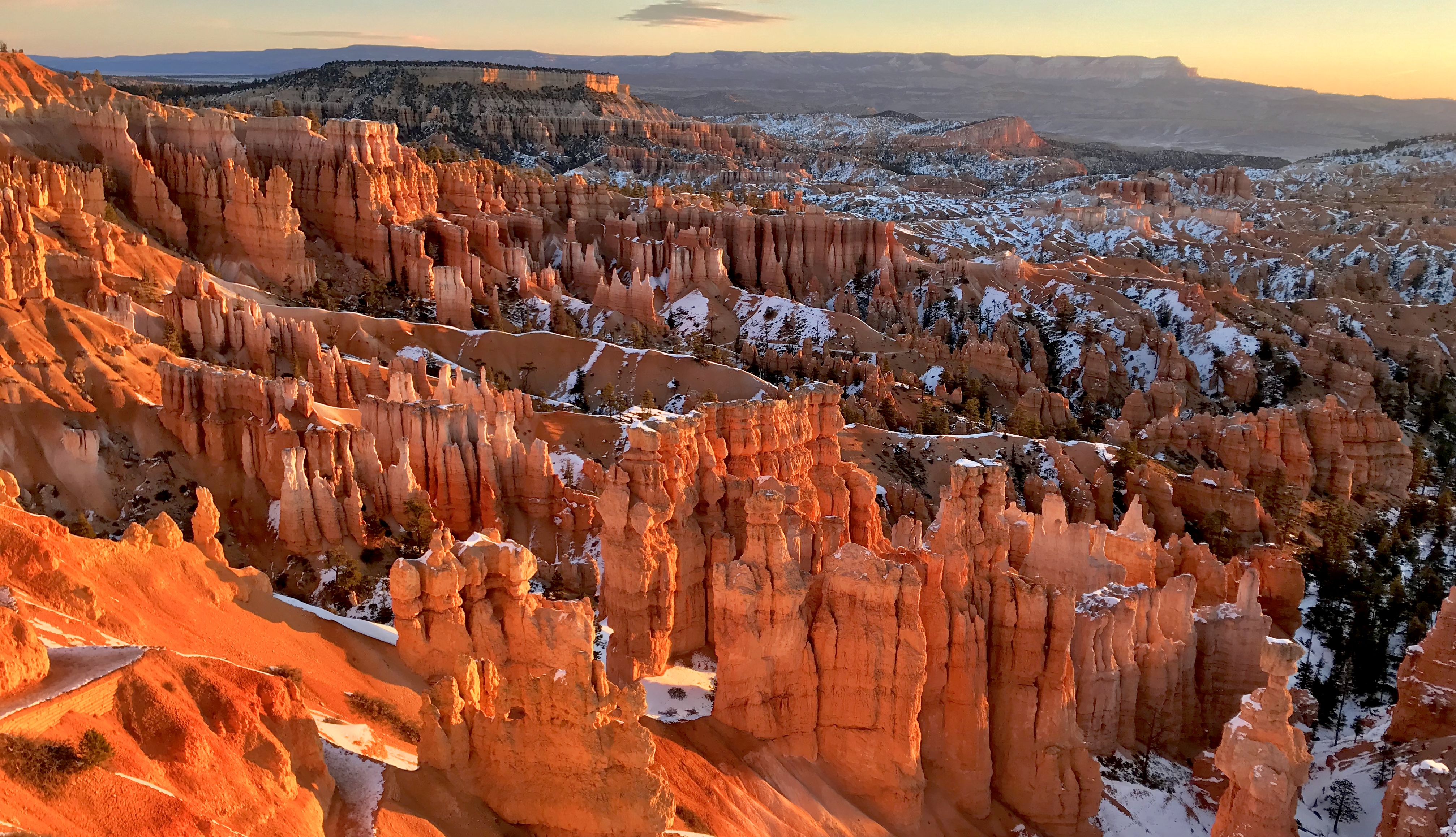
Hoodoos seen from the Bryce National Park’s Sunset Viewpoint. @CateBattles
Known for its distinctive hoodoos and colorful spires, Bryce Canyon’s iconic landscape contains the largest collection of hoodoos in the world. These wild rock towers were created over time with the deposition of several different sediments, including limestone, dolostone, sandstone, mudstone and siltstone. Around 50 million years ago, an ancient lake and flood plain encompassed this region, and sediment from the higher elevations nearby flowed into the flood plain, leaving behind sediment. While this was happening, tectonic plates were subducting, and the major mountain-building event that created the Rockies formed. When the North American plate rose, it created the Colorado Plateau, elevating the once sea-level region to 9,000 feet. With the higher elevation, the landscape was susceptible to ice and rain, and when the water would seep into the cracks, it would freeze and expand, which caused the rocks to break. Over millions of years, the rocks continued to be weathered down and eventually formed the incredible spires they are today.
To get some of the best views of the park, take the scenic drive, where you can enjoy views of hoodoos, arches, and canyons. One of the best hiking trails is the Queen’s Garden/ Navajo Loop that showcases some of the most spectacular scenery in Bryce Canyon and it’s also next to Sunset Point, where you can catch the best light of the day.
7) Mono Lake, California


The Tufas of Mono Lake reach heights up to 30 feet. @CateBattles)
At the intersection of Yosemite’s Tioga Pass and Highway 395, you’ll find one of the West’s most unusual lakes. Just a hop and a skip from downtown Lee Vining, Mono Lake serves up some pretty spectacular views. This large alkaline lake is nearly twice as salty as the ocean, partially because it’s a terminal lake, meaning the lake has no outputs. Though the contents of the lake are interesting, what surrounds the lake is what brings geologists and photographers alike to its shores. Mono Lake is famous for its Tufa formations; bizarre limestone towers created by underwater springs rich in calcium that reach heights up to 30ft. Over the years, the water levels have dropped, exposing these ancient mineral pillars that are scattered along the lake’s perimeter. Though Mono Lake is one of the oldest lakes in North America, it continues to evolve, most recently with the creation of Paoha, a volcanic island in the middle of the lake, which was formed by a series of eruptions around 300 years ago.
While visiting Mono Lake, get a birds-eye view of the Lake and the Eastern Sierra along the Panum Crater Rim Trail, where you can explore a volcanic plug full of obsidian. Speaking of birds, this is a prime spot for bird watching as waterfowl come to enjoy the unique brine shrimp and alkali flies of this salty body of water.
8) Little Wild Horse Canyon, Utah

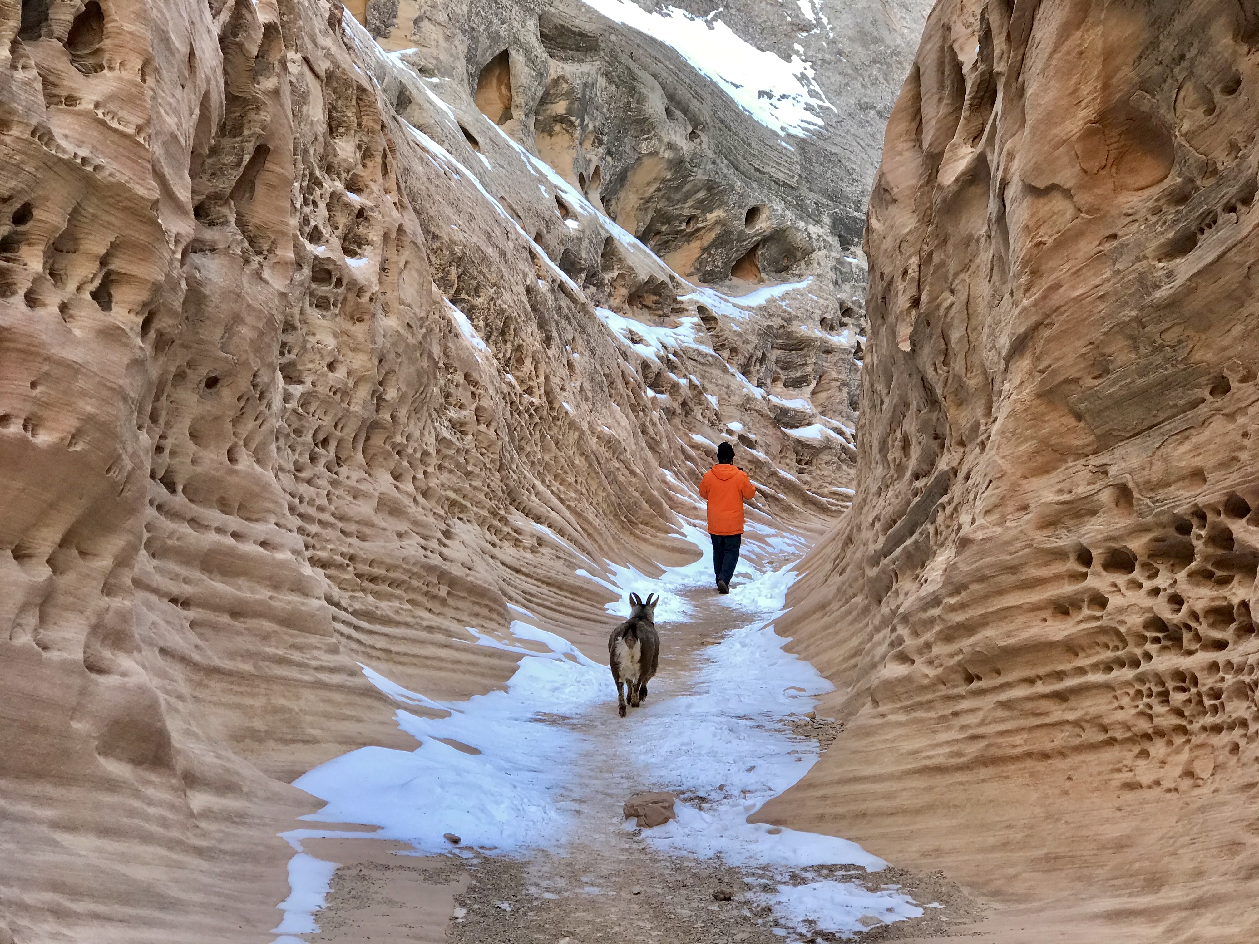
Utah’s Little Wild Horse Canyon is kid-friendly! @CateBattles
Just down the road from Goblin Valley State Park, hidden in the San Rafael Swell, is one of Utah’s best slot canyons. Around 60 million years ago, the region experienced faulting. The rocks below the present-day Swell moved upwards due to tectonic forces, which caused the overlying sedimentary rock to fold into an arched-shaped anticline. Over millions of years, water and wind eroded the geologic layers, resulting in older rocks being exposed in the middle of the Swell. Streams eroded the rock layers to form deep terraced canyons, like Little Wild Horse Canyon.
Unlike many of Utah’s slot canyons, this one is easily accessible on BLM land, along with being family and pet-friendly. While exploring the slot canyon, you can take the 1.8mi trail to the upper end of the narrows before turning around or you can make it a 7.8-mile loop. The slot canyon is anywhere from 20ft across to shoulder length across, so there are a few spots that get very narrow. Like any desert terrain, make sure to check the weather as rain can be dangerous, and remember to bring plenty of water.
9) Alabama Hills, California

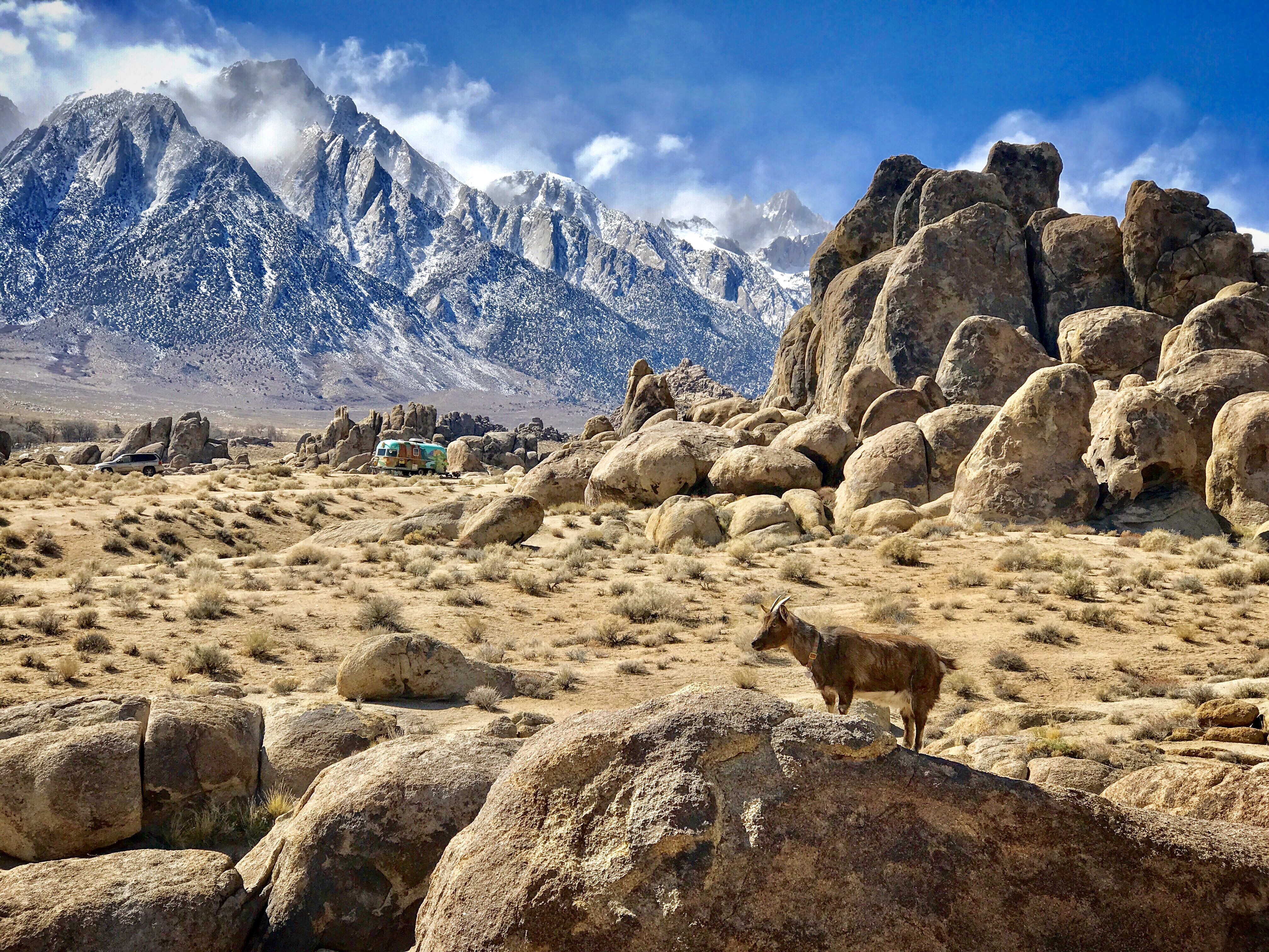
Many movies have been filmed in the Alabama Hills, most famously, “Tremors.” @CateBattles
Nestled below Mt. Whitney, the tallest mountain in the contiguous United States lies one of the nation’s most stunning landscapes—and one with a deceptive name. The Alabama Hills, named after the Confederate warship CSS Alabama, is a range of rounded granite formations starkly contrasting the jagged peaks of its Sierra backdrop. Just a short drive from downtown Lone Pine, this geological wonder sits around 5,300 feet and comprises massive boulders, natural arches, and bizarre rock fins. Though the Alabama Hills appear drastically different than the towering 14,000ft mountains to the west, they are actually the same age and are comprised of the same lithologic identity. The only thing that sets them apart is erosion. At one time, the Alabama Hills was a moist region and the granite rocks were covered by vegetation. However, when the Sierra fault block uplifted around 5 million years ago, it formed the Sierra Mountains, which created a rain shadow. With the lack of precipitation, the region evolved into an arid climate that could no longer support the lush vegetation it once had. When this happened, the rocks became exposed, and spheroidal weathering over time created the rounded granite boulders we see today.
During your visit to the Alabama Hills, make sure to explore Movie Road, where numerous movies were filmed like Tremors, Star Trek, and the Lone Ranger and hike the short loop trail to Mobius Arch.

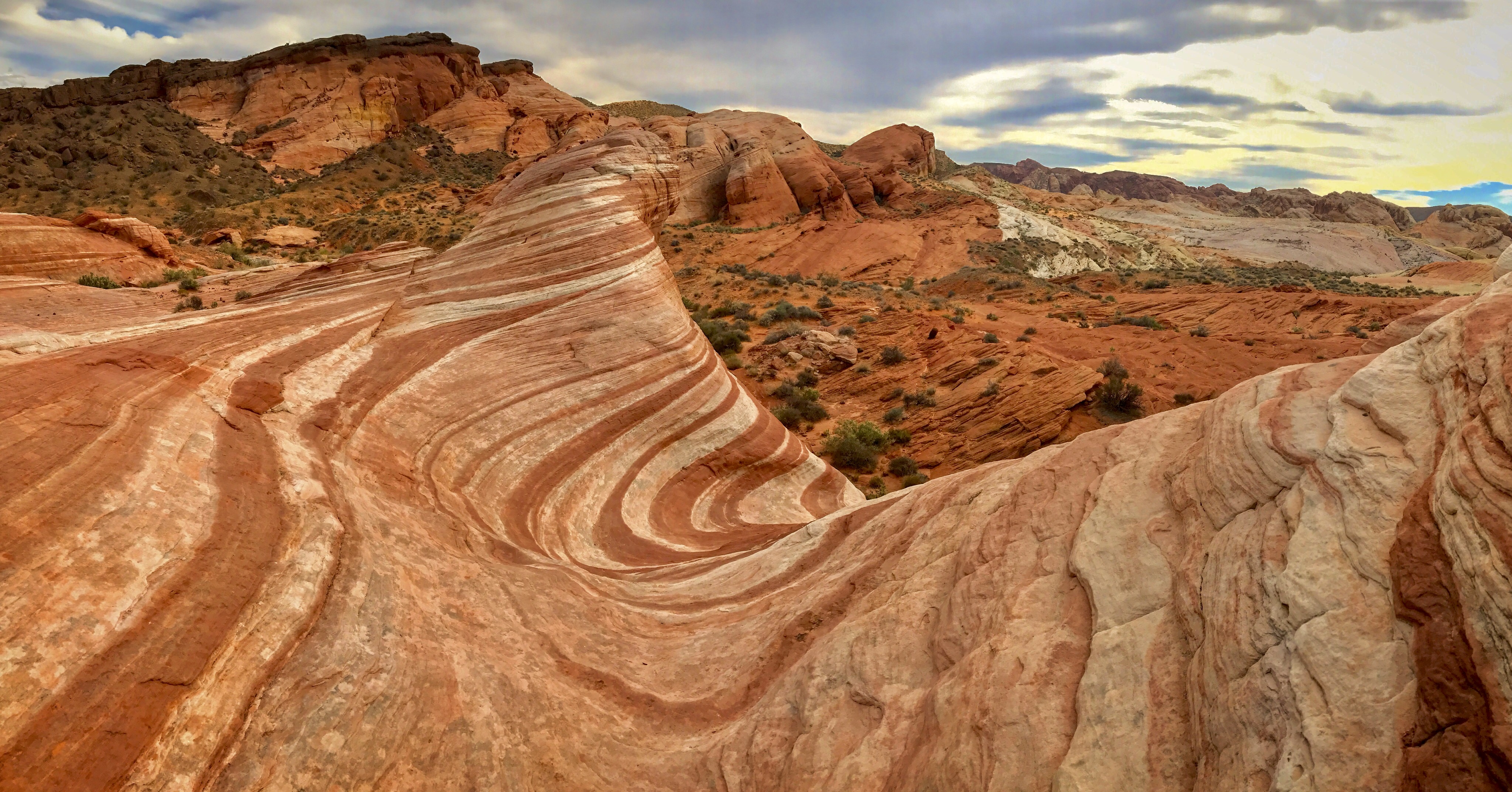
The Fire Wave is one of the most photographed features in the state park. @Cate Battles
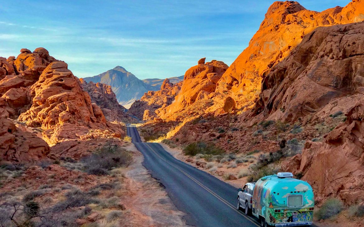
10) Valley of Fire State Park, Nevada
Perhaps the most vibrant state park of the Southwest, Valley of Fire’s magnificent geology sets itself apart from the surrounding landscape Northeast of Las Vegas. Located just down the road from Lake Mead, this 40,000-acre gem of the Southwest is famous for its Aztec sandstone that’s nestled in tan and grey limestone mountains. Dating back to the Jurassic period around 150 million years ago, the region uplifted. The inland sea receded, leaving behind the sand that would eventually become the sandstone you see today. The red color of the rock is a side effect of the iron oxide present in the sediment and really appears to be “on fire” when the early morning or late sun lights up the landscape. Over millions of years, this rock has eroded from wind and other elements, which can be seen in the honeycombed stone around the park.
While exploring the Valley of Fire, some of the best geological features can be found at the Fire Wave, White Domes, and Pink Canyon. In addition, to the gorgeous landscape, the park is covered in ancient petroglyphs dating back 2,000 years, which can be seen along the Mouse’s Tank trail. Like many state parks of the Southwest, pets are allowed on hiking trails, so bring your pupper!