

This is the 11th in a continuing series about our trip through Canada to Alaska
“Those people who turned back are more focused on the destination than the journey.” Monique Zander
WiFi – FINALLY! We haven’t had WiFi available for a few days, including Thursday morning when all power was out in the metropolis of Watson Lake, Yukon Territory. It’s part of the journey. To celebrate being connected again, this edition of Our Alaska Trip blog is divided into two parts: 1) Notes on our travels and 2) Impressions of RVing to Alaska.
CHAPTER 1 – THE LONG, BORING ALASKA HIGHWAY

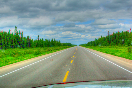
This Is the Scene Before Us for Many of 1,500 Miles of the Alaska Highway
When we left off on our blog two days ago, we were excited about the prospect of feeling the rubber on our 10-ply tires rolling onto the famous Alcan Highway, which is officially the “Alaska Highway” because it was built by the U.S. Army in 1942 to get materiels to Alaska needed to head off a Japanese invasion. It was originally called the Pioneer Highway and the Military Highway … now is officially Hwy. 97.
At about 9:50 a.m. we were on the road headed toward Fort Nelson, B.C., and then the fun began … and faded. During the intervening 283 miles, we saw a Walmart/Sam’s Club truck, the carcass of an animal that had died of boredom, and a bicyclist pumping up his tire on the side of the road at Mile 235. If this was a tough ride for us, we couldn’t imagine what he was going through.
A promised highlight of the drive was the Honey Place, billed as the world’s largest glass beehive. Like many other attraction along the way, it had a CLOSED sign on the side of the building. [We did see a swarm of bees circling the place, probably waiting for it to reopen.]
Earlier in the day we flew past fuel pumps at Pink Mountain, electing to fill up at Sasquatch Crossing since we live in Sasquatch’s cousin, a Bigfoot trailer, but there was no fuel there, so we went about 100 yards to the Husky station, which was closed. It was back to Pink Mountain to fill up at $1.19 per liter. And this is a good time to mention that we now appreciate the advice of filling up the tank whenever you can. We have passed numerous service stations that are closed.
When we entered a patch of farming country after about 200 miles of this monotony, I suggested we might consider agriculture since we were already growing weary. This, the longest leg of the journey so far, could be characterized as a journey between monster trucks carrying large cargo, and, on the good side, the ^^^ signs along the way indicating bumps weren’t as devastating as the previous day’s drive.
Now, please don’t get me wrong. We have been on other beautiful, but monotonous highways in America, and the prospect here of seeing incredible vistas in a day or two keeps us ready for more driving.
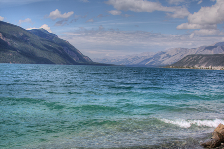
Muncho Lake, B.C. -- Surreal Beauty
We saw no muskeg mires (the name for the deep muck that the Army contended with in 1942) or permafrost, which, as it melts takes the road away with it. As mentioned previously, while in Dawson Creek we watched an outstanding PBS movie about the building of what the American Society of Civil Engineers labeled, “a Historical Civil Engineering Marvel.” Seeing all the pain and pride that went into its construction made us eager start at Mile 0 of the Alaskan Highway.
In the eclectic Fort Nelson Museum there is a mini-theater that features another version of the history of the road, this one much different than the PBS production. This less-polished film filled us in on improvements made after the road officially opened in August 1942.
For a big finish on the day, we walked through Marl Brown’s auto museum. 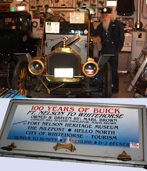


There hasn’t been as much delay as we expected from bad roads or road repairs. There have been a few incidents of damage to caravan vehicles; however, all of them seem to be typical when you consider we are a group of 20 rigs, and the distractions are many. We’ve been lucky.
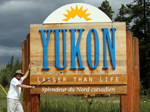

And for me, Wednesday was one of the most important days of the trip: we crossed into Yukon Territory. Lots of people have been to Canada and the number who have traveled to Alaska is incredible. To me, the Yukon has always held a special fascination. It symbolizes wilderness and hardship. After all, it was the patrolling grounds of Sgt. Preston of the Royal Canadian Mounted Police with his heroic dog, Yukon King. No change in scenery since British Columbia, but I’m still excited.
CHAPTER 2– THE RV EXPERIENCE
Tuesday while enjoying the heat of Liard Hot Springs, we met some folks heading back to Manitoba after having a boat excursion cancelled and because two of them were afraid of driving on the high roads. Asked about enduring the boredom ahead going down that same highway, one gentleman replied, “No problem. At our age we can’t remember what we saw yesterday.”
Monique and I have no problem being together for these long hours. Yet, the opportunity to run into other members of our crew at roadside cafes and in the campgrounds makes the trip more enjoyable for us. Another plus for group travel.
Even with fairly manicured roads, this is not a trip for the timid. We met a lady who was begging her husband to turn back because she didn’t like conditions of the private campgrounds. They are overflowing with RVs and tent campers, and although the owners appear to be trying to do everything they can to accommodate their guests, it can get to be a zoo. Remember, they can’t exactly run down to the hardware store to buy items to make repairs. What we’re seeing mostly is trees, with a few rivers and lakes, and every now and then a service station/restaurant without a closed sign, but mainly trees.
If you have a car or RV problem along the way, be prepared for inconvenience. We heard a report of a truck that needed service, and at three repair shops the travelers were invited to make an appointment for the next day or beyond. And, despite the advice of the local mechanics, the repair wasn’t needed.
Lower back pain from being in the vehicle everyday for long hours can creep up on you. Mine was allayed by a dip in the sulfur-rich Liard Hot Springs. I wanted to stay there for two weeks, but our travel schedule wouldn’t allow the break.
And speaking of that, the nature of the planned caravan is that we have little free time, time to rest or do minor changes and repairs to our RVs. Is that good or bad? Well, if we traveled on our own and wanted to stay two weeks in Liard Hot Springs or three days in Dawson Creek to rest up a bit, it would mean that our trip would take longer, and it would play havoc with any reservations for side-trips ahead.
Prices of diesel and gas vary according to the remoteness of the service station from $0.83 up to $2.00 a liter (a liter is just a little over four to a gallon). Food prices also rise as you get further into nowhere, but, in the defense of the owners, their cost of electricity and other services does too. We’ve indulged in very good cinnamon rolls two days in a row.
The weather has been beautiful, warm and party cloudy for most of our journey. I personally welcome the low-hanging clouds as a variation on the theme of abundant trees with beautiful dark green rivers and the Northern Canadian Rockies in the distance.

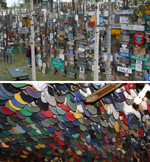
70,000 signs in Watson Lake and 7,500 Hats at Toad River Lodge
From the “Never-Bored RVers,” We’ll see you on down the road.