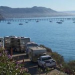
This storied road—the dream trip of a lifetime for many RVers—is a spectacular example of how enduring feats of beauty and genius are born during times of hardship and crisis.
It is a spectacular example of how, during times of hardship and crisis, enduring feats of beauty and genius are born. The concept of a highway that would reach from the “lower forty-eight” all the way into Alaska was just a dream in the 1930s, a fantasy route that would take gold miners and other adventurers and entrepreneurs into Alaska via the Canadian Rockies and the fabled Yukon. By the end of that decade, fear over a Japanese invasion of North America turned the fantasy of some—the Alaska Highway—into a reality for generations to come.
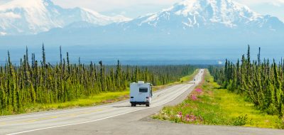
Although most U.S. drivers choose to begin their adventure from Canadian border crossings in Washington, Idaho or Montana, the 1,523 official miles of the Alaska Highway runs from Dawson Creek, British Columbia to Fairbanks, Alaska. The phrase “North to Alaska!” was a battle cry for the nearly 40,000 soldiers and civilian workers who labored for more than two years to create—in record time—a road that still follows much of its original path, created during World War II to get equipment, supplies and men to Alaska to defend against a perceived threat by the Japanese military following the bombing of Pearl Harbor. The highway cost more than $500 million to build, an unheard of sum at that time for road construction, and the men who labored through four seasons of extraordinary temperature changes—from cold winter temperatures reaching as low as -70°F to summer temperatures of 90°F and higher—cleared forest lands, cut through ice and permafrost and blasted mountains to create a highway that would forever link the Continental United States, Canada and Alaska.
The road was originally called the Alaska-Canadian Highway—and is sometimes still referred to as the “Alcan” by locals—but by any name the Alaska Highway is now deservedly considered one of the most beautiful driving routes in the world. With constant road construction and occasional rerouting, the actual mileage of the Alaska Highway has been known to change slightly from year to year and make some road marker points—which are rarely changed—outdated, but one constant always remains; the main, interconnecting roads that make up the Alaska Highway, together with all of the many detour roads available for additional sightseeing along the way, make up one of the most memorable driving tours available to this generation of adventurers.
North to Alaska!
The cheer of “North to Alaska!” may have been started by gold prospectors who flooded the Canadian Yukon and Alaska in the late 1800s and early 1900s and then again by the men and women who built the Alaska Highway, but today “North to Alaska!” serves both as a cheerful greeting among RVers on the trip of a lifetime and as the official name of an organization and website that offers as much information as an individual planning that trip could want. northtoalaska.com is the organization name and website address for tourism boards that service the entire highway route, including Northern British Columbia, the Canadian Yukon and Alaska. The website is chock-full of planning guides, maps, photos and reference information (campsites and RV parks, addresses and phone numbers, hours of business, things to see and do, etc.) that can be printed off or accessed during the trip (a surprising number of RV parks and established camping areas offer wireless Internet access, often for free). The website and accompanying phone number also allow visitors to order a pre-travel packet that can assist in the planning of the trip and accompany you during the adventure.
The North to Alaska website acknowledges that there are at least eleven known—and recommended—routes that those seeking to explore the Alaska Highway and its surrounding countryside can take advantage of, but for purists wanting to stick to the actual 1,523 miles that comprise the actual Alaska Highway, the true journey begins in Dawson Creek.
Mile Zero
Affectionately known as “Mile Zero,” Dawson Creek is the official starting point for most RV travelers, and there’s a Mile Zero signpost in the middle of town that many take advantage of for the initial photograph of the trip; another large sign on Highway 97 proclaims itself the entrance of the Alaska Highway and flies the U.S. and Canadian flags as well as the territorial flags of British Columbia and the Yukon.
Driving north from Dawson Creek, travelers will pass through Fort St. John and Fort Nelson, a route that will see the local economy rapidly change from agriculture to oil and gas production. The next major segment, Fort Nelson to Watson Lake, will follow and cross numerous rivers (bring your fishing gear) and pass by Muncho Lake, a beautiful body of water that owes it’s spectacular blue color to the copper oxides that leach from the local bedrock.
Muncho Lake is a stop-over must, both for its natural beauty—it’s flanked by the Terminal Range of mountains on the west side and the Sentinel Range to the east—and for the opportunity to explore the area by hiking, by float plane or by boat. Tour operators offer guided tours of the lake by boat or plane; there are paddling and raft trips offered on nearby Liard River. Liard River Hot Springs Provincial Park contains one of the most popular hot springs in all of Canada. Campsites are available near the hot springs and in multiple locations around Muncho Lake.
This immediate area has been called the “Serengeti of North America” because of its community of wildlife; bear, moose, elk, caribou, coyotes, lynx and even wolves are routinely seen in or near campgrounds, on the hiking trails and even alongside the highway, munching on grass, berries and bark. Enjoy them from a distance!
From Muncho Lake, travelers continue north through the small town of Watson Lake—perched right on the border of British Columbia and the Yukon territories— and then head west towards the Yukon capital of Whitehorse. Whitehorse is a flat, compact city, complete with Wal-Mart, a regional airport, movie theaters and thrift stores, and also offers great museums, cultural centers featuring First Nation (Native American) art and the kind of souvenir and knick-knack shopping you’ll have trouble finding elsewhere until you reach Dawson City or Fairbanks. Lots of tour operators—especially those geared towards hunting, fishing and flight-seeing —operate out of Whitehorse and prices for tours tend to be a bit more competitive here than in the smaller towns and recreational areas along the highway. From Whitehorse, the Alaska Highway continues west to the small community of Haines Junction before turning north again towards the even smaller community of Beaver Creek and the nearby border crossing into Alaska. The tiny towns that dot the Alaska Highway at this point are great for quick cups of coffee, well-tended campsites and great viewpoints for valleys, mountain ranges and the ever-present wildlife; for many, a multiple-day detour begins by hanging a right at the single Tok, Alaska intersection and taking Highway 5, the Taylor Highway, back east again through Chicken, Alaska (population 35) and over the famous Top of the World Highway into historic Dawson City, Yukon.
A detour to Dawson City is especially worthwhile for history buffs and geology lovers; while the detour means once again going through a customs and border crossing (open only until 8 o’clock in the evening; if you miss the crossing times, plan on camping out at the border overnight) the extraordinary views from the Top of the World Highway out and over hundreds of miles of undeveloped Yukon wilderness, mountain ranges, geologic formations and, depending on the season, wildflowers or changing leaves, is well worth the occasional nail-biting that comes with steep inclines and narrow, winding roads. This road is rough, unpaved and glorious; just figure into your plans a trip that will take you three times longer than the mileage would suggest and enjoy the view as you move along slowly.
Bordellos, Dance Halls, Boardwalks and…Mud
A one- or two-day stop-over at Dawson City may take you off the Alaska Highway proper but you can find there what is pretty tough to find anywhere else these days, namely boardwalks to meander, dance halls with can-can girls, bars galore (including one that offers drinks featuring a freeze-dried, frost-bitten toe as garnish) and some beautifully restored buildings dating back to a time when many of them offered female “companionship” to the weary miners who’d found enough gold that day to buy a beer, a bath and some company.
The boardwalks are not only charming, they can be the only safe way to navigate town during part of the year; the streets—some of them unpaved—are built on permafrost that buckles and “heaves” during spring thaws and, combined with the dust that’s comprised of glacial silt, leaves a concrete-looking mud that sticks to anything it touches and freezes slick in the winter. Don’t be surprised if you enter some buildings and see signs that ask you to remove your shoes in the foyer or on the porch. It’s not a bad idea to do the same before reentering your RV; the grayish mud is the bane of many business owner’s existence and leaves a distinct trace of Dawson City on carpet and linoleum.
On the return trip over the Top of the World Highway—you’ll be pleasantly surprised at how many new things you’ll see going in the reverse direction—and a return to the Alaska Highway will have through-travelers heading north again towards Fairbanks and, technically, the end of the Alaska Highway. Those wishing to continue north can—the highway will change to Highway 11, the Dalton Highway— and follow the Trans-Alaska pipeline all the way up through the famous Brooks Mountain range and eventually end at Prudhoe Bay. Those who’d rather head south towards Anchorage on Highway 3 can then choose to take another route back to the Alaska Highway for a reverse trip or even connect with the Alaska ferry system which will ferry RVs and their passengers down the coastline and all the way to either Vancouver, British Columbia or Bellingham, Washington. Either route back provides ample time to reflect on your Alaska Highway adventure, an opportunity to add to your photograph collection and to forever be able to brag that you were one of the hardy souls that followed their dreams…North to Alaska!