Land of the Oregon Trail
Explore the promised land of the westward expansion
Since the Lewis and Clark Expedition paved the way from 1804 to 1806 for wagon crossings to North America’s West Coast, settlers and adventurers have crossed the continental divide and ventured into Oregon. These days, most people come to this ecologically diverse state to experience its natural beauty, myriad outdoor activities and excellent wildlife-spotting opportunities.
Umatilla
A great place to start any Oregon Trail odyssey is Umatilla County, where the Columbia River spills down from Washington state and turns west to begin its run for the Pacific Ocean. This waterway has made the county a hub for transportation since early times. When Lewis and Clark passed through in 1805, Hat Rock, now a state park, was the first notation in Meriwether Lewis’s journal relating to the mighty Columbia.
The small town of Umatilla sits on the banks of the Columbia, and the outdoor fun is endless. Head to the McNary National Wildlife Refuge to fish for trout, catfish, bass, crappie, bluegill and sturgeon in the area’s sloughs, ponds and streams. Or take a boat out into the wide Columbia River for more fish and phenomenal sightseeing. Visitors with a taste for wine can tour Columbia Crest Winery.
More fishing can be found on the Umatilla River, which flows past the town of Stanfield to its confluence with the Columbia. The stream supports salmon and trout for fishermen. Nearby is the Cold Springs National Wildlife Refuge, an oasis of birdwatching, horseback riding and picnicking around a beautiful, secluded lake.
The tiny hamlet of Stanfield, 12 miles south of Umatilla, lies between Hermiston, known for its watermelons, and the county seat of Pendleton. The Umatilla County Fair serves up rides, produce and agricultural exhibits every August in Hermiston. Juicy melons procured from roadside stands around Stanfield have been a staple for generations, but America’s largest fruit isn’t the area’s only crop: Vineyards can be seen throughout Umatilla County.
Pendleton
When most people hear the name Pendleton, they think of Pendleton blankets, the city’s most popular export. Whether you’re interested in picking up a blanket or just want to experience a bit of history, don’t miss a visit to the Pendleton Woolen Mills, which offers free 20-minute tours of the mill four times a day on weekdays. The attached mill store is the best place in town to buy Pendleton wool and features a huge selection of the company’s famous blankets, some significantly marked down in price.
While Pendleton blankets are certainly an important symbol of the city, there’s plenty more to do and see here beyond the mills. The area has a large Native American population, and the Tamástslikt Cultural Institute is a good place to familiarize oneself with the indigenous traditions and cultures of the area. The museum offers permanent exhibits of the area’s tribes past and present along with a shop selling traditional beadwork made by local tribes.
The city is at its most popular during the second week of September, when the annual Pendleton Round-Up attracts tens of thousands of out-of-town visitors for a wide range of rodeo events and a large parade.
Baker City
Further south along the I-84 toward Idaho, quaint, historic Baker City is characterized by block upon block of 19th-century buildings. The city boasts upward of 100 buildings on the National Register of Historic Places. The most noteworthy of these is the Geiser Grand Hotel, which opened in 1889 with a number of modern features (for the time) including electric lights and a working elevator. The Baker Heritage Museum is another important site for history buffs, with a rotation of exhibits on everything from wildlife to mining, plus a great selection of historical photos that show how few parts of the cityscape have changed in the past century and a half.
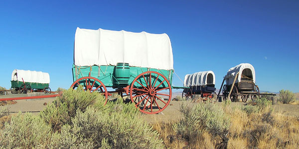
Just east of town, the National Historic Oregon Trail Interpretive Center is a great place for kids and adults alike to learn about the history of the Oregon Trail, with exhibits, historical demonstrations and 4 miles of hiking trails. This facility features 12,000 square feet of galleries that transport visitors along the 2,000-mile journey of the Oregon Trail, with lifesize trail dioramas, replica wagons, and authentic artifacts.
The permanent exhibit galleries take visitors through the experiences of preparing for the journey, life on the trail, interaction between emigrants and natives, dangers and challenges, settlement and homesteading in Oregon.
The exhibits are self-guided and include interactive displays and several short interpretive videos. Plan a minimum of one hour to thoroughly tour the main exhibits, and an additional 20-30 minutes for any special exhibits that may be on display during your visit.
Other highlights include a wagon encampment with six replica wagons, and if you visit over the Labor Day Weekend, you can watch costumed actors recreate life on the trail.
While in Baker City, go on a historic walking tour to many of the 100 buildings that have been preserved by the town . Discover the city’s history as a vital point in the western expansion of the United States. The town’s Destination Downtown project has preserved several structures and streets.
High Desert Discovery Scenic Byway and the East Steens Tour Route
One of the best ways to experience the natural beauty of eastern Oregon is by taking a drive along the 127-mile-long High Desert Discovery Scenic Byway, which starts in the small town of Burns off Highway 20 and continues south through some of the region’s most beautiful natural scenic areas.
When Harney County was sliced out of the eastern Oregon high desert, it became the ninth largest county in America. Bigger than some states, only about 7,000 people call Harney County home and most of them live in Burns or its neighbor Hines. This is ranching and timber country, the likes of which namesake Scottish poet Robert Burns never imagined.
North of town, the Malheur National Forest boasts the largest tracts of ponderosa pine in the nation. Recently the area’s challenging terrain—some canyons drop more than 1 mile—has hosted the nationally famous Steens Mountain Running Camp.
Lovers of wildlife will find a paradise in the Malheur National Wildlife Refuge, south of Burns and one of the most popular spots for bird-watching in the Northwest. This 187,757-acre sanctuary was launched under President Theodore Roosevelt and is a wonderful place to spot migratory birds and waterfowl, along with dozens of species of mammals. The huge refuge encompasses a mix of desert, grassland and marsh, and it’s a major stop-off for swans, geese, ducks, cranes and pelicans following the Pacific Flyway. The refuge’s George Benson Memorial Museum is an ideal spot to learn more about the area, with exhibits and taxidermy specimens of the area’s avian species.
The refuge constitutes a small percentage of the Northern Great Basin’s total acreage but is a tremendously important source of wildlife habitat relative to other portions of the Northern Great Basin. The refuge represents a crucial stop along the Pacific Flyway and offers resting, breeding and nesting habitat for hundreds of migratory birds and other wildlife. Many of the species migrating through or breeding here are highlighted as priority species in national bird conservation plans.
Further south along the Byway is the community of Frenchglen, which provides excellent insight into Oregon’s Old West. This old ranching homestead has many old buildings, including the 1924 Frenchglen Hotel, which operates as a hotel in the spring through early fall. Other area attractions include the Donner und Blitzen River, and while you shouldn’t expect to see any of Santa’s reindeer here, you can take advantage of some excellent fishing for redband trout, a desert subspecies of rainbow trout.
Nearby, the Pete French Round Barn State Heritage Site is a state park that showcases a unique barn design. The structure was designed and constructed in 1880 by Peter French, a cattle baron who established a sprawling cattle empire that dominated the region for more than 25 years. The circular barn is supported by several giant juniper posts; an outer circular track provides a wintertime exercise area for the horses.
Further south along state Highway 205 is the Steens Mountain Wilderness, a sparsely populated area where it’s not uncommon to spot desert bighorn sheep and wild mustangs. Occupying 170,200 acres, this area is one of the wildest and most remote regions of the Beaver State.
The centerpiece is Steens Mountain, almost 10,000 feet high with an east face composed of basalt rock piled up from millions of years of volcanic activity. This recreational mecca includes a series of hot springs scattered around the 50-mile-long mountain.
The route continues through the Catlow Valley, ending in the ranching community of Fields. From here, a good way to get back north to the Burns area is to take the East Steens Tour Route, a 143-mile stretch of road that, when combined with the High Desert Scenic Byway, forms a loop.
The route heads north through the Alvord Desert, an unusually barren moonscape that’s popular for ATV riding and even sand windsurfing. North of here is Alvord Hot Springs, which has a number of well-maintained soaking pools. Further north along the drive, several small lakes draw in additional wildlife near Crystal Crane Hot Springs. Be sure to take time for a soak in the warm waters before continuing back to Burns.
For More Information
Travel Oregon
800-547-7842
www.traveloregon.com

